
Flood Risk Assessment for Zone 3 Development
A thorough design, analysis and optimization process conducted during the preliminary stages of an infrastructure project will save time and money throughout the entire lifespan of a project. Consulting engineers conducting pre-planning services prefer Civil Designer because it incorporate the terrain, rainfall data and relevant infrastructure within the same design model thereby upholding a realistic simulation of the entire project.
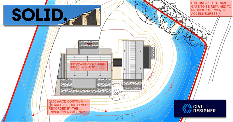
When UK engineering firm SOLID Structures & Infrastructure were required to conduct pre-planning services to demonstrate that the proposed ground profile of a residential development in Oxfordshire would provide the equivalent flood storage as the existing ground profile they chose to use Civil Designer to model the site.
The software’s advanced terrain modelling features quickly and effectively allowed them to model the site and create the assessment drawings and verification visualizations necessary to demonstrate that the Flood Zone level 3 development requirements were met. Flood Risk, Drainage & Urban Water expert Argemiro Rivera explains:
“The SOLID infrastructure team have been busy helping clients submit planning applications and calculate the earthworks costs at the preliminary design stage. Flood Risk Assessments for developments located in Flood Zone 3 need to demonstrate that the proposed ground profile can provide at least the equivalent amount of flood storage as the existing ground profile.
The volume comparison needs to be assessed on a level for level basis so that the drainage officer is confident that there will be no reduction in the capacity for flood water from the existing ground profile.
Using Civil Designer software, we have been able to build an electronic ground model to compare the respective volumes for a private residential site in Oxfordshire and present the results on a drawing to help the drainage officer visualise the conditions for each scenario.”
Excerpt taken from: https://solid-engineering.co.uk/news/pre-planning-services
View the project demonstration which explains how Civil Designer’s Flood Levels feature allows the CAD footprint of a structure to be positioned above the recorded flood level in order to assess the potential flood risk: https://youtu.be/QZe9si8_xeE
Find other Civil Designer showcases and client testimonials here: www.civildesigner.com/showcases/